

Projects Review
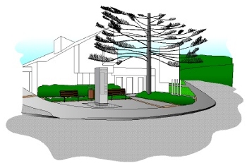
![]() Northern Suburbs Heritage Trail
Northern Suburbs Heritage Trail
Early in the formation of the Society it recommended the reprinting of the WCC’s heritage trail booklet about the Northern Suburbs as this was then out of print. It was also recommended that it should be reproduced in two parts :
• for Kaiwharawhara / Ngaio, Khandallah, etc.
• for Johnsonville, Grenada, Middleton Road and Tawa
During 2002 the Society was approached by the Wellington City Council for input regarding the re-editing and incorporation of additional material for the new booklet which was being planned for reissue and now needed information about Tawa as the most northerly suburb of Wellington. The Society was able to provide considerable input and through 2003 contributed to the discussion with Council of this publication for the Tawa areas.
Towards the end of 2004 the Society celebrated the final issue of this publication, by Wellington City Council. It now comprises two booklets titled ; Part 1 “Around the Kaiwharawhara Basin”, and Part 2 “Following the Old Porirua Road”, with Part 2 including the Tawa features. We were delighted that the first of our objectives as a society was achieved, and thanked the City Council for their work in this matter.
Click here for the details of the Tawa heritage features included in this publication.
![]() Tawa Information Boards
Tawa Information Boards
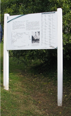
Early on the Society considered the need for the provision of a large display board on or near the Tawa Library suggesting a Northern and a Southern historical trail through Tawa. This concept is based upon the Heritage Trail Information Boards provided elsewhere in Wellington City; e.g. at Seton Nossiter Park regarding the Belmont Viaduct and that next to Twigland Garden Centre on Middleton Road regarding the Glenside area and the “Halfway House” still standing there. Tawa missed out on the original Heritage Information Board scheme undertaken by Wellington as it wasn’t at that time part of Wellington City.
WCC concept drawing of the site upgraded Library corner with location of the Heritage Information panels.
This concept was discussed with Barbara Fill, Heritage Officer for Wellington City Council, who was receptive to the idea in principle. During 2003 With the grateful assistance of Rod Clark through the drafting and planning stages the Society prepared a ‘mock up’ of suggested material for this Board and this was provided to the Council’s Heritage section for the production of the final board design and graphical layout.
Delay has occurred through 2004 as the Council considered the redesign of the style of their heritage information board scheme.
At our March 2005 meeting officers of the Council informed us of the plans to upgrade the area on the corner of the Main Road and Cambridge Street adjacent to the library. This upgrade includes the building of a tall lit structure which will contain maps and written information about the Heritage Trails we have proposed, as well as realignment of kerbing, new seating and lighting and some landscaping of this area. Construction was expected to be undertaken late 2005.
The installation of the information panels at the Tawa Library site was finally completed in November 2009. But alas it wasn’t long before one of the panels were vandalised and smashed and the display was removed again for repair before being reinstated early 2010.
Other proposed sites for the placement of further information boards in Tawa have also been considered by the Society :
• At Tawa Cemetery to detail its origins as a gift of Edward Gibbon Wakefield; its site for a Church, and noting those buried there. Some progress was made on the content on this information board during 2008 with WCC and the information panel installation completed early 2009.
• In Grasslees Reserve, to draw attention to Elsdon Best; to the Best farm of Grasslees; and to the early agricultural practices of pioneer settlers. Some progress was made on the content on this information board during 2008 with WCC.
• On the corner of the Main Road and Oxford Street, to draw attention to that area as the first “town centre” of Tawa with the General Store, Post Office, garage, Tawa School, first church, Leigh’s stockade and “town hall” all situated nearby.
• On the site of the first Tawa Railway Station on Duncan Street 100-200 metres north of the new roundabout at the Duncan Street / Taylor Terrace / Tawa Terrace intersection. This would draw attention to the Wellington and Manawatu Railway through Tawa, the line of the old track, the 1937 railway deviation and its impact on Tawa.
• Outside the Linden Social Centre.
• Near the Bucket Tree / Takapu Station.
• At Charles Duncan Reserve Fyvie Avenue, on this reserve site and the contribution of the Duncan family - completed during 2008.
At each of these sites information could be given regarding adjacent or nearby sites of historical interest.
![]() Tawa Walking map
Tawa Walking map
As part of the preparation of the Tawa Library Information Board the Society has proposed two possible historical trails through Tawa. Both will start at the Mervyn Kemp Library. The first walk will be a “Northern Circuit”, and the second a “Southern Circuit”. The proposed routes have been agreed with the Council Heritage Section. A map of these “Trails” has been prepared as part of the Information Board project and a version of these maps is available at Tawa Library thanks to our printer Porirua Print. Reprints are periodically made as demand requires.
![]() Old Porirua Road trail – footprint marker plaques.
Old Porirua Road trail – footprint marker plaques.
The first significant post 1840 activity in the Tawa area was the construction of the Old Porirua Road. Cleared and built during the 1840s and supported by stockades (Middleton’s, Leigh’s and Elliott’s), it linked Wellington and the small settlements of Porirua and Paremata on the Porirua Harbour. The road eventually evolved into the old Centennial Highway (State Highway 1). The Old Porirua Road can be traced through Tawa along some streets (Middleton Road, Willowbank Road, Boscobel Lane, Main Road, Oxford Street, Grasslees Reserve, Main Road again, Duncan Park, across Linden Avenue to Linden West Park and back to the Main Road).
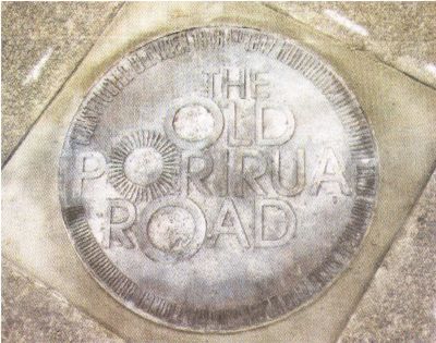
Old Porirua Road trail marker plaques
At an early stage in its formation the Society considered ways in which this road, so important to the development of Tawa, could be appropriately marked. The outcome is the Old Porirua Road footprint marker trail project. This involves the placing of 12 brass plaques set into concrete at appropriate spots along the route through Tawa, similar in concept to those marking the original waterfront through the Wellington CBD.
During 2003 the Society made application to the Pelorous Trust for a funding grant, and, to our delight they have granted us $3,500 towards this project. However, the approval process was slow as each spot needed to be carefully checked for cables, drainage and other essential bits of city infrastructure that may lurk hidden beneath the footpaths.
During 2004 a plan of the exact proposed locations for the plaques was prepared. This was provided to the various interested Council departments, and other utility service providers of water, drainage, electricity and telecommunication etc. in the vicinity in order that the required approvals to proceed with the laying of the plaques can be given.
Laying of the plaques was finally completed during early 2007. See here for an associated press article.
![]() Tawa Cemetery
Tawa Cemetery
Cemetery Information Board
Early in 2004 we noted that Tawa Cemetery on the Main Road near Fyvie Avenue had a difficult and potentially dangerous access, and the perimeters in particular need a good clean up having become overgrown in places. This was brought to the attention of the Wellington City Council.
Later in 2004 the Council completed a project to install all weather access steps into the cemetery from the Main Road. At the Tawa Community Board meeting of 8 June 2006 representation was made with regards to regarding signage for the Tawa Cemetery.
Subsequent further improvements sought by the Society and made by the WCC Parks Department during 2007-8 have included :
• Repairs to and painting of the front fence,
• Erection of a new fence on the southern boundary,
• Removal of noxious weeds and some small trees and regular mowing of the site.
The Society continued working with the Council with regards to :
• The establishment of an Information Board to describe the background of this place, detailing it is a gift of Edward Gibbon Wakefield; its site for a Church, and noting those buried there. Some progress was made on the content on this information board during 2008 with WCC and the information panel installation completed early 2009.
• Identification of the correct location of the western boundary which, at some time in the past, has seen a retaining wall built (of rubber tyres) which both encroaches on the cemetery property, and on to some of the graves.
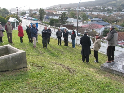
Cemetery book launch ceremony 31 July 2009
A booklet about those buried here and the gifting of the land was completed and published in June 2009. A small ceremony to mark the booklet launch and to give thanks to the WCC for completion of the information board and other works to date at the cemetery was held at the cemetery in late July 2009, followed by refreshments at the Community Centre.
For a listing of known burials at Tawa Cemetery see here.
If you any information of interest regarded to any burial in the Tawa Cemetery please contact the webmaster at webmaster@tawahistory.wellington.net.nz.
As a result of our approach to the Wellington City Council, Council officers in early 2010 had a bench seat placed in the Cemetery. We are very pleased with the level of support and cooperation we receive from the City Council and its officers.
![]() Heritage register of significant buildings and sites
Heritage register of significant buildings and sites
A subcommittee of the Society executive has been steadily gathering information and photographs on significant buildings and sites within Tawa and neighbouring areas. These include :
• old farm houses (the Nott’s, Greer’s, and Harrison’s Homesteads off Middleton Road, the Hyde’s and Woodman’s houses in Takapu Road, Brown’s House, Thomas Hook’s House, and Mexted’s Stone House),
• old public buildings (Tawa School, Takapu Road School, the Railway Station [now 65 years old] and the site of the original Tawa Railway Station, shops on the corner of Main Road and Oxford Street, and the old Town Hall), and the sites of the early military stockades,
• old homes (Bartlett’s, Shilling’s, Mexted’s (corner Oxford Street and Sussex Street)) as well as other sites like Elsdon Best’s memorial, the WW1 memorial in Willowbank Park and the old railway houses in Duncan Street.
Our aim is to describe the history of these houses and / or sites, to photograph them, and perhaps to publish a booklet regarding them, and / or place the information on our website.
During 2009 good progress was made by committee member Mike Steer on material for a booklet on the Bartlett house and it is planned that this will be completed and published early 2010. Committee member Pat Waite has also been researching material for some of the other older Tawa buildings also the Tawa Town Hall which featured prominently in the social life of early Tawa and may become the subject of a future booklet.
If you any information of interest regarded to any of these buildings or sites or any others in Tawa that we ought to be considering place contact a member of the Executive committee.
![]() Old railway route
Old railway route
Transport was key to the development of Tawa and after the Old Porirua Road, the Wellington – Manawatu Railway through Tawa and Granada North and later the North Island main trunk deviation provided many employment opportunities in the area as well as stimulating the eventual urbanisation of the Tawa valley. This project seeks to publicise the original railway route through Tawa, the remaining features from the original construction period and the influences the railway had on the development of Tawa. Also see under Information Boards.
In conjunction with railway enthusiast David Parsons the publican of Rails Through the Valley came to fruition at the end of 2008.
Congratulations are also due to David Parsons on his authorship of Wellington’s Railways: Colonial Steam to Matangi. This is a superb and quite detailed overview of the development and maintenance of the railway system in the Wellington region, and is well worth purchasing. It is available through ‘Take Note Tawa’, or from ‘Mack’s Tracks’ on the Plimmerton Station. The cost is $57.50.
![]() Takapu Road WWII Army Ammunition Depot
Takapu Road WWII Army Ammunition Depot
Phil Harland headed up a project to research the U.S. military ammunition depot that it is understood existed off Takapu Road during the stay of the U.S. forces in Wellington during WWII. Following a request for further information from members in Newsletter #4 in 2002, a number of people came forward with supporting reminiscences. We were indebted to the late Brian and Graham Mexted, and Murray Henderson for the information they contributed. This was confirmed by the recollections of John Woodman on page 39 of the booklet “I Remember Tawa” by Barbara Adams, who is quoted as saying “The Americans were up there (Takapu Valley) during the war and there was a lot of activity then. They had a big ammunition dump and a rifle range.”
Although New Zealand records and archives provide details of U.S. Military bases in Porirua, Kapiti and Wairarapa, as yet official sources, such as N.Z. Ministry of Works records have failed to show up any reference to this Takapu depot, but we have seen a 1944 aerial photograph of the Tawa Interchange and Grenada North area and in this there appears to be confirmation of some activity such as that so far described by witnesses, located on a side road South off Takapu Road where previously Horn’s pig farm was located.
The Takapu Road, Tawa, U.S. Marine Depot was described by locals as an : Ammunition Dumb, Rifle Range, Store (for food and clothing) and a Depot for Road Making Machinery. Perhaps in a minor way it was all those things but inquiries continued into the activity at this depot.
Phil Harland continued to pursue this elusive quarry during 2005 and 2006 which resulted in a booklet on the Takapu Ammunition depot being published early 2008. This booklet was revised in 2023.
Phil would still appreciate hearing from anyone further having further information about this small U.S. military base during the 1942–45 period. (Phil can be reached on 04-232 8157, Email: pandeharland (at) xtra.co.nz).
![]() Society Website
Society Website
In May 2005 the Society launched its own website, with the assistance from committee member and webmaster Richard Herbert. It is our aim that the latest news regarding the Society’s projects will be regularly posted on the website along with other information gathered of interest to the history of the area, for the information and use of the community and future generations.
Comments on material posted and other contributions of interest are keenly sought and should be emailed to the webmaster though the contact link below.
![]() Charles Duncan Reserve
Charles Duncan Reserve
Charles Duncan Reserve is a small reserve (0.76 ha) located at 2B Fyvie Avenue on the north western footslopes of Tawa between Turriff Crescent and Main Road Tawa and hitherto unnamed. It was the residual part of Section 52 that became the Lindenvale subdivision undertaken by the Duncan estate.
Section 52 was originally purchased by Charles Duncan in 1866. As a trained horticulturalist, Charles continued his trade on their farm he called ‘Linden Vale’ after a favourite spot of his in Kew Gardens, constructing a garden and nursery around their home. His son Stuart Duncan continued to live on the property and subsequent to his death the farm became the Lindenvale subdivision and this remaining portion was vested in the then Tawa Borough Council as Recreation Reserve in 1981.
Following an interest in the Duncan family by the Society, and after consultation and approval by the family, the name of Charles Duncan Reserve was suggested to the Wellington City Council in 2005 in recognition of the influence that Charles Duncan and his family had on the development of northern Tawa. This was approved by Council in May 2006 and, in collaboration with the Friends of Tawa Bush Reserves and the Wellington City Council, work was commenced to bring the reserve back from the overgrown neglected state that had hitherto befallen it. Over the following four years much of the weeds and rubbish has been removed and around 1,000 local grown native trees planted, a reserve name and information board signage added and an access track developed. The Society contributed content for the information board in conjunction with Wellington City Council Heritage Department. In June 2006 the Tawa Historical Society received a grant from Tawa Community Grants of $1,087 towards the cost of a reserve information board signage and improvements to the entrance track. With information supplied by the Society the reserve information board was installed by WCC during 2008. Further native tree plantings and weed maintenance will continue to be undertaken by the Friends of Tawa Bush Reserves.
A small ceremony was held at the reserve on 6 December 2009 to recognise of progress thus far and to open the access track provided. We hope that in the future neighbours and the people of Tawa may be able to enjoy this small enclave amongst suburbia as Charles once did and that it may also provide a significant contribution to supporting the increased native bird population that Tawa now enjoys and a remembrance to one of our pioneer families and the contribution they made to the development of Tawa.
![]() Willowbank Park
Willowbank Park
During 2009 the Society made further representations to the Tawa Community Board and the Wellington City Council Heritage Section with regards to an information board near Boscobel Lane and possible name change for this area from Willowbank Park to William Earp Park. At the Tawa Community Board Meeting of 13 August 2009 it was noted that such a change would require a public consultation programme and an alternative option also noted. Keep the existing name but name the orchard within the Park as it keeps a long established name and identifies the significance of the site and the role of William Earp in the area. This enables interpretation of the site and the significance of the orchard. Earp was the early settler who successfully farmed the land; his orchard comprises a good part of the park, and its fruit trees are still there bearing fruit; he planted the Bucket Tree; he was a respected citizen; his grandson was killed at Gallipoli; and he is buried, with his wife, in the Tawa Cemetery.
It should also be noted that on Saturday 13 September 2008 a planting ceremony was held to plant seven heritage apple trees at Willowbank Park playground area. These had been specially created and grown to gradually replace the park’s dying fruit trees that are thought to have been originally planted by early settlers. Cuttings were taken from some of the trees a few years ago and the trees that have been developed from them are now at a stage where they can be planted. Bruce Murray represented the society and spoke about the heritage of the Boscobel area.
Discussions continued with WCC through 2010 regards the erection of an information board in the Park. The Park and the area surrounding it is full of historical interest, and the Society may consider a book or booklet about this area. It has Maori connections; gave the name to Takapu Valley and the harbour-to-harbour Maori trail passed through the reserve. It saw two railway tracks built on either side of it, one the Wellington-Manawatu Railway track ran nearby in the mid-1880s, and the other, the present line was built as part of the Tawa Deviation in the mid-1930s with Takapu Station opening in June 1937. Nearby Boscobel Lane is part of the Old Porirua Road. The park is a small part of the original farm of William and Elizabeth Earp, and contains the remnant of their original farm orchard. The Bucket tree, planted by the Earps in the mid-1860s, is a Tawa icon. Nearby stood McCoy’s Stockade, built to protect those, Maori and pakeha, who were building the Porirua Road in 1846-47. More recently, Arohata Borstal was built nearby in 1944.
![]() Community Grants
Community Grants
Over the years the Society has been successful in being awarded a number of community grants. These include the following:
• November 2003, from Pelorous Trust, $3,500 towards the cost of design, manufacture and setting into concrete of 12 plaques to mark the route through Tawa of the original Old Porirua Road. The balance was gratefully paid by the Wellington City Council.
• January 2006, from Tawa Community Grants, $1,000 towards the cost of printing of its book The Streets of Tawa.
• January 2006, from Tawa Community Grants, $3,000 towards the cost of printing of its book An Historical Atlas of Tawa.
• June 2006, from Tawa Community Grants, $700 towards the cost of scanning and photographic services from Micrographic Services related to the publication of its book An Historical Atlas of Tawa.
• June 2008, from Tawa Community Grants, $1,500 towards the cost of Quantity Surveyor to asses costs for Tawa Memorial.
• May 2012, from Tawa Community Grants, $2,141 towards costs of preparing photographic displays for the proposed 2012 Tawa Historic Week.
• May 2019, from Tawa Community Grants, $1,000 towards the cost of printing of its book Takapu Valley
![]() Tawa Memorial
Tawa Memorial
Following the 2007 Anzac Day ceremony at which our publication Lest Tawa Forgets was launched and the Memorial Oak Tree Plaque laid in Oxford Street an idea was conceived for there to be a Tawa Memorial that would form a more fitting focus point for the outdoor part of the ANZAC celebrations. At present the memorial for the 13 serviceman from Tawa that died representing NZ is on a wall in the Tawa RSA building. Bruce Murray briefed the Tawa Community Board of this idea at its meeting of the 14 June 2007 and received approval in principle to progress the proposal.
After some discussion a Tawa Memorial Project was formed and a subcommittee comprising representatives of the Society, the Tawa RSA and the Tawa Community Board was established to progress a proposal. Late 2007 the subcommittee asked an architect, Callum McKenzie of McKenzie Higham, Wellington, to prepare initial concept plans of what a memorial might look like. We gave Callum a broad design brief and he brought his people out to measure up the proposed site at the end of Oxford Street adjacent to both Grasslees Reserve and the Tawa RSA. Callum commenced work and provided some draft plans early 2008.
At its meeting on 10 April 2008 the Tawa Community Board resolved to reconfirm its support the project and work with the members of the project committee to present a proposal and to engage with WCC offices to assess its feasibility. And in June 2008 the Tawa Historical Society obtained from Tawa Community Grants $1,500 to enable a Quantity Surveyor to asses costs for the Tawa Memorial. However, at a cost of over $100,000, it was deemed to be too expensive to proceed with further at this time and the project will be taken up again when the economy is in a more favourable position for fund raising.
![]() “Tawa History Week”
“Tawa History Week”
2012 was the fifth year that the Tawa Historical Society as run its “Tawa History Week”, in conjunction with the Mervyn Kemp Library which provides the venue and refreshments before each talk. This continues the good working relationship the Society has with the Tawa Library who also publicise and sell our books. The “Tawa History Week” initiative was inaugurated in 2008 to bring greater awareness of local history to Tawa residents and provide an opportunity for them to learn some of that fascinating history of the area in which the live. The talks also relate to the research members of the society are currently undertaking. The programme has normally ran as follows:
10.15 - 10.30am each day – a cup of tea/coffee.
10.30 - 11.30am a talk / lecture or on one day, an historical walk within Tawa.
For 2012 there is proposed to be a change of style to an Information Display which will run for a longer two-week period.
Tawa History Week 2008 ran during the first week of August and provided a talk each day of the week which went very well with approximately 80 people attending over the five days. Topics for each day were : Monday – The Tawa Flat Cemetery 1867 - 1978; Tuesday – Elsdon Best 1856 - 1931; Wednesday – The Takapu Road Ammunitions Bunker; Thursday – Tawa Flat’s Bartlett Family and House; Friday – An historic walk and talk around central Tawa.
Tawa History Week 2009 ran for four days, June 2 to 5, following Queens birthday weekend. Topics included: Tawa Cemetery and the Tawa Cemetery Booklet; Bartlett House; Willowbank Park and environs.
Tawa History Week 2010 ran for four days, June 8 to 11, following Queens birthday weekend and went well, with small (8-12) but appreciative audiences. Topics for each day were : Tuesday – Bruce Murray – The English forebears of A H (Arthur) Carman; Wednesday – Philip Harland – Updated information on the Ammunition Bunker and Railway line in the Takapu vicinity; Thursday – David Wood – Arthur Carman’s politics; Friday – Bruce Murray – Arthur Carman’s father.
Tawa History Week 2011 was once again scheduled to run for four days, Tuesday 7 June to Friday 10 June, following Queens birthday weekend. Topics scheduled for each day were : Tuesday – a virtual bus tour around some of Tawa’s historical spots by Phil Harland; Followed on Wednesday - Friday with three talks by Bruce Murray on aerial photos of Tawa (Flat) from 1943, 1959, and 1965; two of Arthur Carman’s forebears; and thirdly about some photographs of Tawa taken in the years between 1901 and 1954. However, after the first days talk the remaining events unfortunately had to be cancelled due to a member’s illness.
Tawa History Week 2012 is to be more in the style of an Tawa History Information Display through photographs located in the Tawa Library over the period, 5 to 15 June, following Queens birthday weekend.
![]() Tawa Railway Station
Tawa Railway Station
During 2010 the executive thought of “doing something with the Tawa Railway Station” building. We have noted that at the Plimmerton and Paekakariki stations activities of an historic nature have been permitted.
The Tawa Railway Station renovation continues to interest us through 2011, with Phil Harland, Pat Waite and David Parsons taking a special interest in this possibility. Realising that any such project would be beyond the financial capability of the Society the committee also engaged with the Tawa Community Board and the Rotary Club of Tawa for support. We understand that there will be a public meeting on this matter in March 2012 to ascertain the level of public support for such a renovation.
Meanwhile Greater Wellington as current owner of the building are assessing the cost of refurbishment of the building including replacing its roof and damaged piles and realigning the building which is sunk about 10cm on one corner. The cost of this work may make it beyond worthwhile restoring.
![]() Tawa Lookout Historic Walk
Tawa Lookout Historic Walk
On the 20th February 2011 the Society in conjunction with the Rotary Club of Tawa supported a community walk from the Tawa Library to the Tawa Lookout and return. We wrote a brochure, which was available to all walkers, pointing out items of historical interest along the route and which was jointly funded with Rotary. Bruce Murray also provided a historical commentary at a few selected points along the route. The walk was very well attended by around 200 members of the community.
![]() Historical Bus Tours
Historical Bus Tours
On two autumn Saturday afternoons in 2011, our Society played host to bus tours of “Historic Tawa” by members of the Wellington branch of the Historic Places Trust. Originally planned as one tour, it proved so popular that another was immediately planned. A total of 110 HPT members thus enjoyed Tawa’s history. Our thanks go to Phil Harland and Pat Waite who planned, organised, and hosted the tourists; to Rotary’s Inner Wheel who arranged afternoon teas for each tour; and to Richard Herbert who manned the “bookstall” for each occasion. We received a donation from HPT, and sold our publications to those who came on the tours.
![]() The Tawa (Flat) Historical Calendar
The Tawa (Flat) Historical Calendar
The Tawa (Flat) Historical Calendar for 2012 was a pretty successful venture. Including the cover, there were 13 black and white photographs of Tawa (Flat) dating from 1901 to 1965. They covered a variety of subjects – the railway, some individuals, panoramas across the valley, the ‘town centre’, and aerial photos, some of which are obliques, and others are verticals. A most attractive calendar for 2012 resulted with the design and layout handled by Wendy Cameron and Porirua Print were once again our printers
There was something of interest for everyone and it made a marvellous Christmas present. We commenced sale with an initial print run of 100 in October, and they sold out quite quickly at $20. We printed another 40, and after running a stall on the footpath outside the Lotto shop on a Saturday in December, the last were sold before Christmas.
![]() Publications
Publications
One of the aims of the society has always been to educate the Community about aspects of historical significance in the Tawa area, and to achieve this through publications about relevant and interesting aspects of history in the Tawa area.
During 2004-5 the Society gathered information on the origins of Tawa Street names. This resulted in the Society’s first publication, The Streets of Tawa, being published in November 2005. See here for an associated press article. See here for a list of Tawa Street names and a summary their origins. This booklet quickly became out of print and a revised and updated edition was published in November 2021.
Subsequently to this first publication the Society has attempted to release a publication about annually. A complete list of Society publications and other publication about Tawa can be found at the Tawa history page.
All of our publications really require someone with writing, editing and historical skills to head up such ventures. Any offers would be welcome? Some will also require further funding or sponsorship support.
Comments on material posted and other contributions of interest are keenly sought and should be emailed to the webmaster though the contact link below.
Members of the Society are welcome to offer other suggestions for consideration as regards the future directions and projects of the Society or a special interest that they may have some expert knowledge about.